
Hurricane Vance strengthens; Southwest storms in focus: Weather briefing for October 23, 2026
Hurricane Vance strengthened to 85 mph in the eastern Pacific early Friday, while the main U.S. hazard centered on severe thunderstorms and heavy rain from New Mexico into southern Colorado. Farther east, coastal flooding remained a concern along parts of the Southeast and Mid-Atlantic, and smoke continued to affect air quality in multiple states.
Past 24 Hours
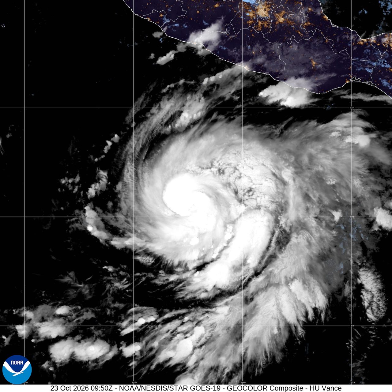
Hurricane Vance became a hurricane by 3 a.m. CST Friday, centered about 440 miles south-southwest of Acapulco, Mexico, with top sustained winds of 85 mph, the National Hurricane Center said. The storm was moving north-northwest at 6 mph, and forecasters said rapid intensification was likely to continue through the day. There were no coastal watches or warnings in effect with the latest advisory, but swells from Vance were forecast to begin reaching parts of southern and southwestern Mexico this weekend and continue into next week, raising the risk of life-threatening surf and rip current conditions.
Across the U.S. Southwest, more development was expected through Friday. The Storm Prediction Center said a slight risk of severe thunderstorms covered parts of New Mexico and southern Colorado, with hail, damaging wind gusts and a tornado or two possible into tonight. The same setup was also feeding a flash flood threat. The Weather Prediction Center said a slight risk of excessive rainfall covered parts of the southern High Plains and Southwest on Friday, with urban areas, roads, small streams, narrow canyons, gullies and burn scars most vulnerable to localized flash flooding.
Wildfire activity stayed more limited than in peak summer, but smoke was still a national air-quality issue. AirNow carried an alert for wildfire smoke affecting air quality in multiple states on Friday, with officials directing users to the national fire and smoke map for local conditions. At the same time, the National Interagency Fire Center reported nine large fires under suppression nationwide, with 390,083 acres burning in large fires as of Thursday evening.
What's Happening Now
Vance remained the most organized tropical system in the hemisphere covered by the National Hurricane Center on Friday morning. Hurricane-force winds extended up to 35 miles from the center, and tropical-storm-force winds extended up to 205 miles. The track kept the center offshore for now, but the storm's growing surf field was expected to reach the Mexican coast this weekend.
In the continental U.S., the most active corridor was from New Mexico into southern Colorado. The Storm Prediction Center's Friday outlook called for multiple rounds of thunderstorms, with supercells and clusters capable of producing large hail, damaging gusts and a tornado or two. This matters because the same storms are moving over terrain and burn-scar areas where heavy rain can turn quickly into runoff problems.
Along the Atlantic coast, the National Weather Service said coastal flooding impacts could continue through the weekend along parts of the Southeast and Mid-Atlantic. In southern Florida, heavy showers and thunderstorms were expected to increase this weekend, with localized flash flooding possible in low-lying and urban spots.
Outlook Through Tonight
Through 11:59 p.m. ET, the highest U.S. forecast concern remains the Southwest and nearby High Plains. The Storm Prediction Center said severe thunderstorms would continue across parts of New Mexico and southern Colorado today into tonight, with hail as the primary hazard and isolated strong wind gusts and a tornado or two also possible. The Weather Prediction Center kept a slight risk of excessive rainfall over the same broader region, pointing to localized flash flooding where repeated storms develop.
Over the eastern Pacific, Vance was forecast to keep strengthening and become a major hurricane by tonight, according to the National Hurricane Center. Even without watches or warnings in effect Friday morning, the storm will be watched closely for changing coastal risk as it tracks north-northwest offshore of Mexico. In the western Pacific, the Guam forecast office reported no active tropical cyclones and no watches, warnings or advisories in effect across Guam and the Marianas Friday night local time.
Smoke will also remain part of the weather picture into tonight in parts of the U.S. where wildfires are active or upwind smoke is present. AirNow's national alert for wildfire smoke in multiple states remained in place Friday, a reminder that the day's hazards were not limited to rain and wind.

