
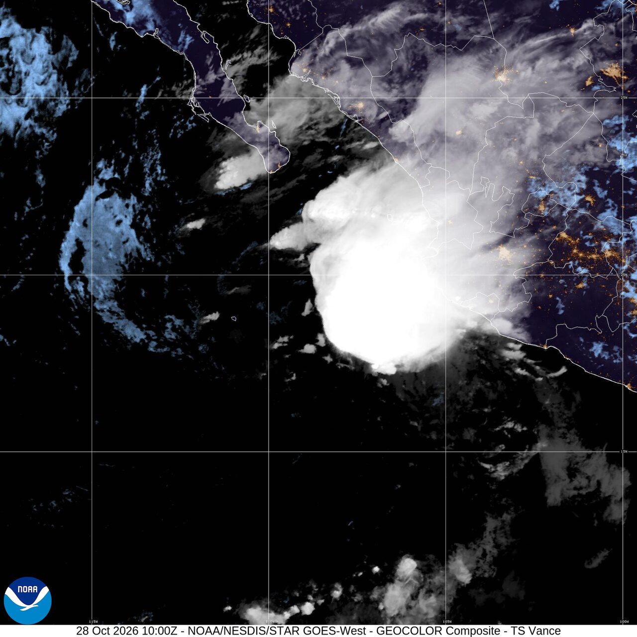
Tropical Storm Vance nears western Mexico: Weather briefing for October 28, 2026

Tropical Storm Vance was the leading tropical story Wednesday, holding at 40 mph as it moved north about 225 miles west-southwest of Cabo Corrientes, Mexico, early in the day. Elsewhere, coastal flooding developed in parts of Florida during king tides, smoke alerts remained posted in multiple states, and forecasters outlined a slight severe weather risk over parts of the Upper Mississippi Valley for late Wednesday into early Thursday.
Past 24 Hours
Along Mexico's Pacific coast, Tropical Storm Vance remained offshore through the latest National Hurricane Center advisory at 2 a.m. MST Wednesday. The center was near 18.6 north and 108.6 west, moving north at 12 mph with a minimum central pressure of 1003 mb. Maximum sustained winds held at 40 mph. The National Hurricane Center said no coastal watches or warnings were in effect with that advisory.
In Florida, coastal flooding developed in low-lying spots during the latest round of king tides. Reports circulated from parts of South Florida and other Atlantic coast communities as saltwater pushed onto roads and into drainage-prone areas. The flooding mattered because it affected travel and neighborhoods without a rain-producing storm overhead, a reminder of how vulnerable the coast can be during high tide cycles.
What's Happening Now
Vance was still the main active tropical system in the eastern Pacific on Wednesday morning. The storm stayed well offshore of western Mexico and had no watches or warnings posted, but its path kept it close enough to the coast for residents and marine interests to monitor updated advisories. The National Hurricane Center's headline said Vance was holding steady on a northward track.
Across the United States, AirNow kept a national alert in place for wildfire smoke affecting air quality in multiple states. The site did not list all impacted locations in the page summary, but the national alert signaled that smoke remained a broad health issue for sensitive groups and, in some places, the general public.
The National Interagency Fire Center's latest national update listed eight large fires being suppressed across 398,011 acres, with one new large fire added in the previous reporting cycle. Those numbers pointed to an active but not extreme late-season U.S. fire picture, even as smoke continued to drift far from fire lines.
Outlook Through Tonight
The Storm Prediction Center placed parts of the Upper Mississippi Valley under a slight risk of severe thunderstorms through early Thursday. Forecasters said a few storms could become severe, with some tornado potential along with isolated large hail and damaging winds.

The Weather Prediction Center showed a marginal excessive rainfall risk on Wednesday, pointing to isolated runoff problems rather than a widespread U.S. flood setup through tonight.
Nationally, the broader pattern favored wet weather in the Pacific Northwest into the northern Rockies, where the National Weather Service said a Pacific storm would bring rain and high elevation snow. In Alaska, another series of storms over the Bering Sea was expected to bring strong winds, heavy precipitation and elevated water levels along parts of the west coast into northern sections of the state.


