
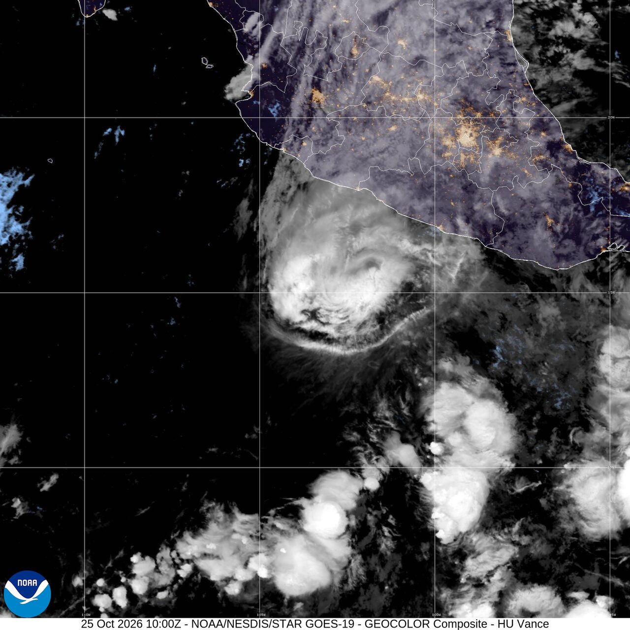
Hurricane Vance nears Mexico; heavy rain targets Florida and the southern Plains: Weather briefing for October 25, 2026
Hurricane Vance was the day’s main weather threat, holding 85 mph winds early Sunday as it moved north-northwest at 5 mph about 295 miles southwest of Acapulco, Mexico, the National Hurricane Center said. In the United States, heavy rain remained the top near-term concern, with a slight risk of excessive rainfall covering more than 7.1 million people and a marginal severe storm risk posted from central and eastern New Mexico into far west Texas. Wildfire smoke also continued to affect air quality in multiple states.
Past 24 Hours
Vance strengthened into a hurricane over the eastern Pacific during the past day and stayed offshore south of Mexico. At 3 a.m. CST Sunday, the center was near 14.3N and 103.4W, with maximum sustained winds of 85 mph and a central pressure of 980 mb. The National Hurricane Center said Vance had weakened slightly by the latest advisory, and that no coastal watches or warnings were in effect.
Elsewhere, the National Interagency Fire Center’s latest national snapshot listed 10 large fires being suppressed across 408,431 acres, updated Saturday morning. AirNow also kept a national alert in place for wildfire smoke in multiple states.
What's Happening Now
Heavy rain is active across two parts of the United States. The National Weather Service highlighted southern Plains rainfall this weekend and another heavy-rain corridor in South Florida. The Weather Prediction Center’s Day 1 excessive rainfall outlook shows a slight risk area with at least a 15 percent chance of rainfall exceeding flash flood guidance, covering about 7,132,324 people, plus a broader marginal risk affecting another 6,411,204 people.
Severe thunderstorm potential is more limited but still present in the southern High Plains. The Storm Prediction Center posted a marginal risk for parts of central and eastern New Mexico and far west Texas through early Monday. Its forecast called for isolated large hail, a tornado or two, and isolated damaging wind gusts this afternoon and evening as a slow-moving boundary and modest instability support scattered supercells.
Across the eastern Pacific, Vance remains the main organized tropical hazard near North America. The hurricane was moving north-northwest at 5 mph early Sunday, and the National Hurricane Center said no coastal watches or warnings were in effect. Because the storm is still offshore, the immediate risk is concentrated over water and along parts of Mexico’s Pacific coast.
In Alaska, the National Weather Service said a Bering Sea storm was still bringing heavy precipitation, strong winds and minor to major coastal flooding to western parts of the state through the weekend. That keeps western Alaska in the active-hazard picture even as the lower 48 focus stays on rain and a few severe storms.
Outlook Through Tonight
Through 11:59 p.m. ET tonight, the wettest U.S. spots are expected to remain in South Florida and from New Mexico into adjacent parts of the southern Plains. Flood-prone urban areas, low-water crossings and places that have already seen repeated rounds of rain will be most exposed if bands train over the same corridor.
The severe threat should stay isolated, not widespread, but any storm that holds together over New Mexico or far west Texas could produce hail of 1 to 1.5 inches, a brief tornado, or an isolated damaging wind gust. The Storm Prediction Center said confidence in a broader outbreak is limited because instability may stay patchy under cloud cover.
Vance is expected to stay a hurricane or strong tropical cyclone near southwestern Mexico tonight while moving slowly north-northwest. Any shift closer to the coast would raise the risk of tropical rain and surf impacts quickly, so the storm will remain the key system to watch into tonight.

