
Global Weather Briefing for October 1, 2026
Flooding was the dominant weather story in the Americas today, with south-central Texas facing the highest U.S. flash-flood threat as repeated heavy rain spread along a slow-moving front. Globally, the most serious confirmed impacts remained deadly flooding in Crete and the continuing fallout from major inundation in Bangkok, where recent heavy rain caused widespread disruption.
Past 24 Hours
Among the most consequential weather impacts confirmed during the past 24 hours was flooding on the Greek island of Crete. Multiple published reports described floodwaters sweeping through villages in the Mylopotamos area, damaging roads and bridges, flooding homes and businesses, and leaving at least one person dead. Conditions were still hazardous late in the day, with some communities cut off and emergency crews continuing operations.
In Thailand, flooding in and around Bangkok remained a major international weather story after extreme rainfall over recent days. Published reporting said heavy rain inundated parts of the capital and contributed to broader national flooding impacts, including business disruption and transportation problems. Even where water levels begin to improve, the scale of urban and economic disruption keeps this event among the most significant global weather developments under discussion today.

In the United States, the most notable observed impacts were tied to heavy rain in North Texas. NBC DFW reported that more than 150 flights were canceled at DFW Airport early Thursday as a rainstorm affected airport operations, with additional delays and a ground stop also reported. Those disruptions underscore how quickly today’s rain threat translated into real-world infrastructure effects even before the highest forecast flood totals materialized.
What’s Happening Now
The most urgent active U.S. hazard is the heavy-rain and flash-flood threat across the southern Plains, especially Texas. The National Weather Service homepage highlighted heavy rainfall and severe thunderstorms in the southern Plains, while the Weather Prediction Center’s Day 1 Excessive Rainfall Outlook placed portions of south-central Texas in a Moderate Risk area for excessive rainfall through Friday morning. WPC said widespread 3-inch-plus rainfall is possible, with locally higher totals and hourly rates capable of producing significant flash flooding, especially from the Hill Country into the I-35 corridor.

Severe thunderstorm risk itself is comparatively limited today. The Storm Prediction Center said organized severe thunderstorm potential is low, though some strong storms with gusty winds could develop from Kansas into Texas. In other words, flooding is the primary life-safety concern, not a broad outbreak of destructive severe weather.
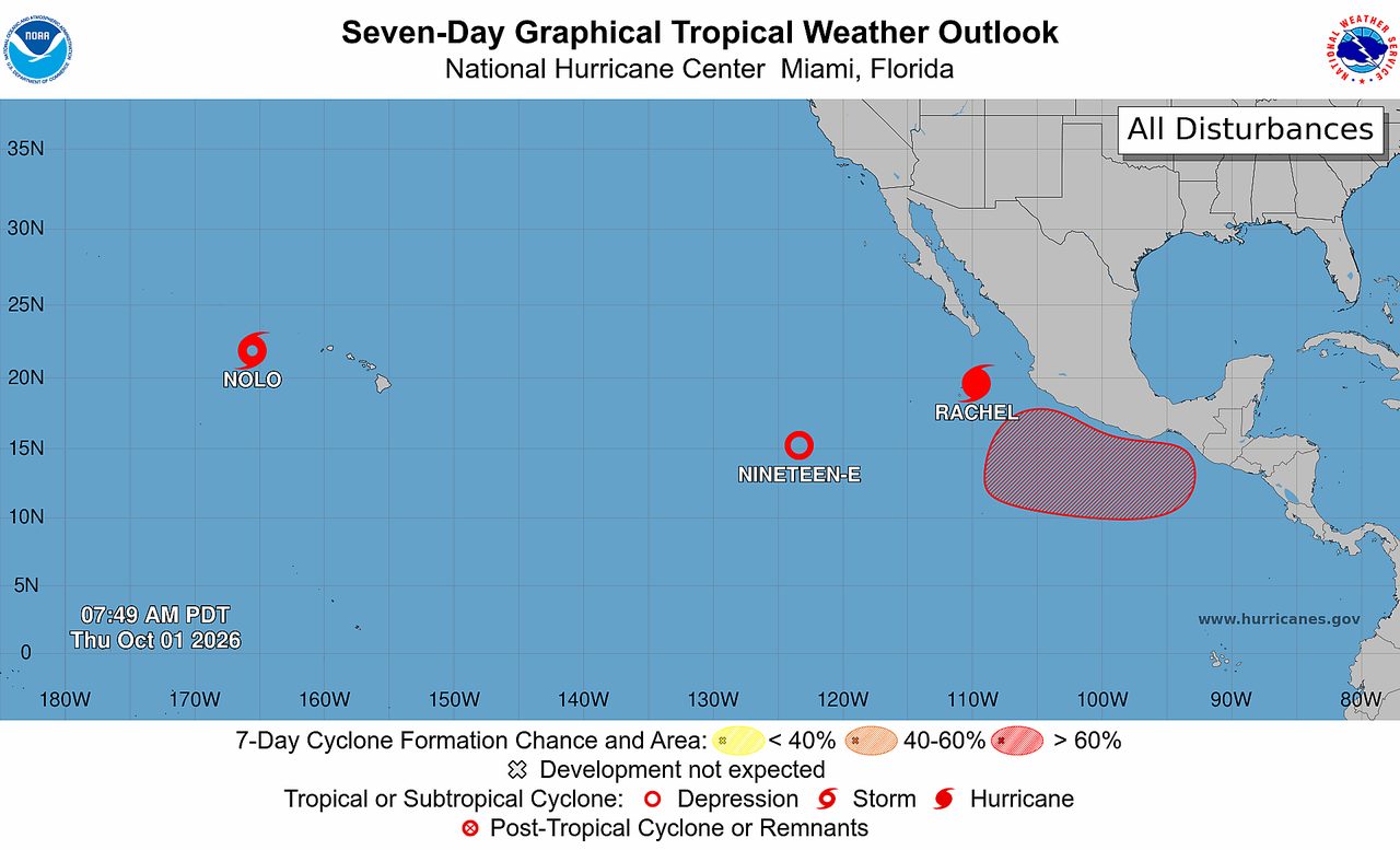
In the tropics, the Atlantic remains quiet for now. The National Hurricane Center’s 8 a.m. EDT Atlantic Tropical Weather Outlook said tropical cyclone formation is not expected over the next seven days. The eastern and central Pacific are more active, with NHC issuing advisories on Hurricane Rachel, Tropical Depression Nineteen-E, and Tropical Storm Nolo. Based on the latest NHC text products, these systems were not the top global weather story today because the strongest verified land impacts in the current window were tied instead to flooding events.
Wildfire concerns in the U.S. are present but not leading the national picture. The Storm Prediction Center’s Day 1 Fire Weather Outlook forecast no critical fire-weather areas, while AirNow continued to flag wildfire smoke impacts in multiple states. That means smoke remains relevant for air quality, but today’s top U.S. weather threat is still flooding rain.
Outlook Through Tonight
Through 11:59 p.m. Eastern, the highest-confidence weather risk remains additional flooding in Texas and nearby parts of Oklahoma. WPC’s outlook says the slow-moving front and deep moisture will support repeated rounds of rain, with the potential for training storms and locally significant flash flooding. Travel disruptions, flooded low-water crossings, and rapid water rises remain the key concerns into tonight.
Elsewhere in the U.S., thunderstorms may still produce gusty winds in parts of Kansas, Oklahoma, and Texas, but the broader severe-weather setup is not especially robust. Fire-weather conditions are also not expected to reach critical thresholds today.
Across the tropical Atlantic, no new cyclone development is expected tonight. In the eastern Pacific, NHC also noted a low-pressure area could form south of southern Mexico later this weekend or early next week, but that is a later-period concern rather than a tonight hazard. For the current period, the biggest weather stories remain flood response in Texas, ongoing recovery from deadly flooding in Crete, and the broader disruption tied to recent flooding in Bangkok.


