
Global Weather Briefing for October 13, 2026

Global weather hazards remained active through Tuesday, October 13, led by Hurricane Simon off western Mexico, an expanding heavy-rain and severe-storm setup across the central United States, and continuing wildfire and smoke problems in Indonesia. Official U.S. forecast centers also highlighted additional rain and mountain snow in the West, while smoke alerts remained in effect in parts of the United States.
Past 24 Hours
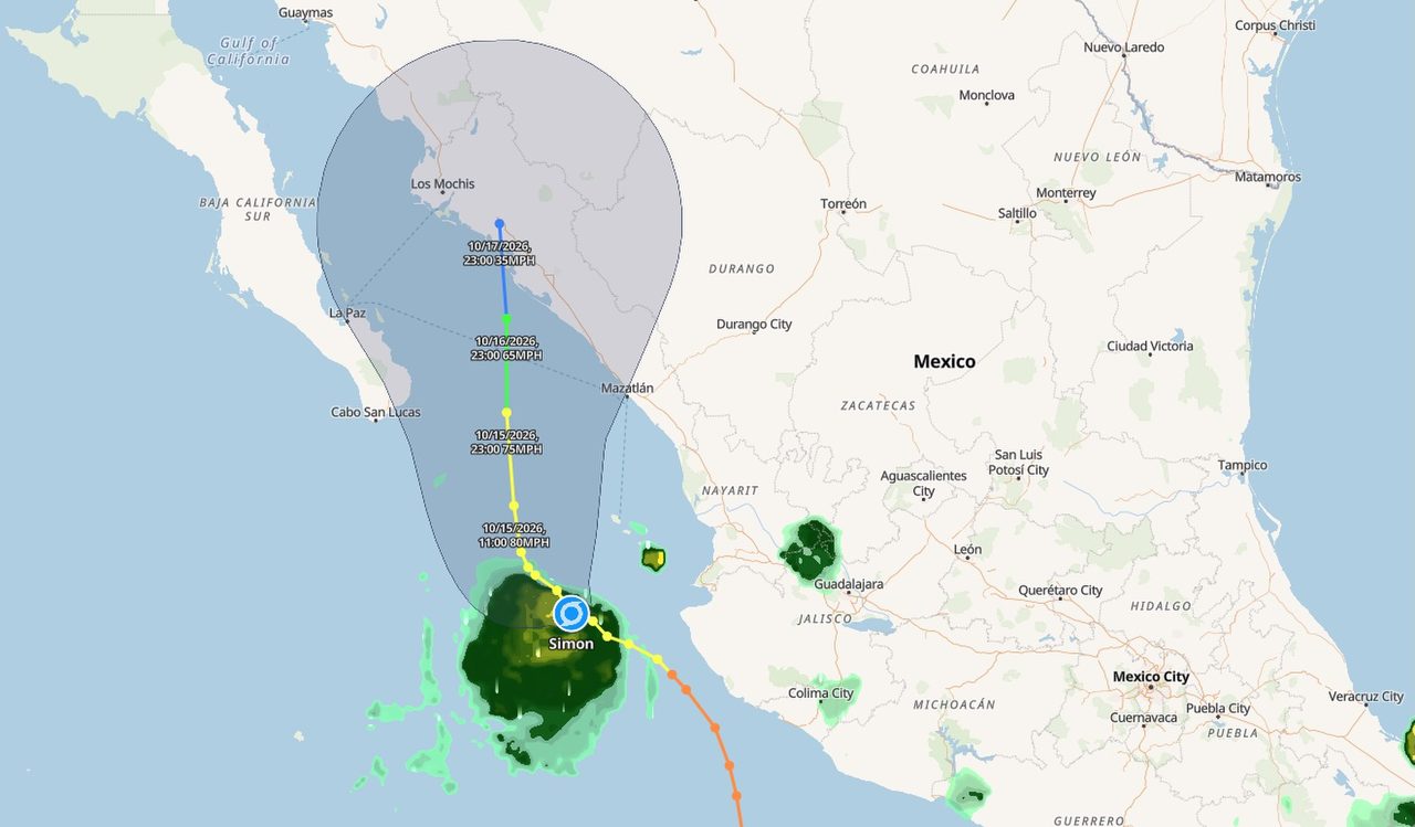
Hurricane Simon remained the most significant verified weather event in the region over the past day. The National Hurricane Center said Tuesday morning that Simon was a hurricane located about 100 miles west of Cabo Corrientes, Mexico, moving very slowly and still posing a risk of torrential rain near parts of the Mexican coast. NHC’s latest public information listed Simon near 20.4°N, 107.2°W with maximum sustained winds of 90 mph and a minimum central pressure of 977 mb.
In the United States, unsettled weather shifted from the Rockies toward the Plains. The Weather Prediction Center said a slow-moving pattern would support several days of heavy rainfall and scattered flash flooding from the Corn Belt to the Texas Big Bend, while the Storm Prediction Center forecast widely scattered severe storms capable of large hail, damaging winds, and possibly a tornado from parts of the central and southern Plains into the Lower Missouri Valley. These are ongoing hazards rather than a single confirmed disaster in the past 24 hours, so impacts should be viewed as developing.

Farther afield, wildfire smoke remained a major weather and air-quality concern in Indonesia. Reporting carried by AFP and published by The Star described weeks of peatland fires in parts of Indonesian Borneo, with haze affecting air quality locally and across neighboring countries. The article cited Copernicus Atmosphere Monitoring Service data showing unusually high fire emissions this season, underscoring that the smoke problem remains regionally significant even though precise day-by-day impact totals were not independently confirmed here from a primary agency bulletin.
What’s Happening Now
As of Tuesday morning U.S. time, Hurricane Simon remained active in the eastern Pacific while no tropical cyclones were present in the Atlantic or central Pacific basins. NHC also noted a separate low-pressure area south of southern Mexico with a near 100 percent chance of development over 48 hours and seven days, meaning the eastern Pacific remains busy even beyond Simon itself.
Across the U.S., national guidance continued to emphasize a corridor of active weather from the southern High Plains into the Midwest. SPC’s Day 1 outlook called for a slight risk of severe thunderstorms from parts of northwest Missouri and Kansas into the southern High Plains, with large hail and damaging winds the main threats and a tornado or two possible. WPC also maintained a slight risk area for excessive rainfall in its national hazards summary, while AirNow posted a system alert for wildfire smoke affecting air quality in multiple states.

Indonesia’s fire season also remained active, with smoke from peatland burning continuing to affect parts of Borneo and the broader region. Because the available reusable image located for this article is from an earlier but closely related Indonesia peatland-fire episode, it is shown as representative imagery rather than as a direct image of today’s smoke conditions.
Outlook Through Tonight
Through 11:59 p.m. ET, the clearest U.S. forecast concern is the overlap of severe thunderstorms and heavy rain from the central and southern Plains into the Lower Missouri Valley. SPC said scattered severe storms are expected this afternoon into tonight, with large hail and damaging winds as the primary hazards and a limited tornado risk. WPC’s short-range discussion said several days of heavy rainfall and scattered flash flooding are possible from the Corn Belt to the Texas Big Bend, with storm-total rainfall of 2 to 4 inches through Thursday in some areas.
Along the Mexican coast, Simon is expected to remain a closely watched hurricane hazard, especially for heavy rain. Interests in west-central Mexico were urged by NHC to continue monitoring forecast updates. Elsewhere, the Atlantic remains comparatively quiet, and SPC’s fire-weather outlook showed no critical fire-weather areas forecast for today across the continental United States, although locally elevated conditions were noted in parts of California.
Overall, the global weather picture through tonight is defined less by one single worldwide disaster than by a cluster of high-impact hazards: an active hurricane near Mexico, a broad U.S. corridor vulnerable to heavy rain and severe storms, and persistent wildfire-smoke impacts in Indonesia and parts of the United States.


.png)

.jpg)