
Global Weather Briefing for October 11, 2026

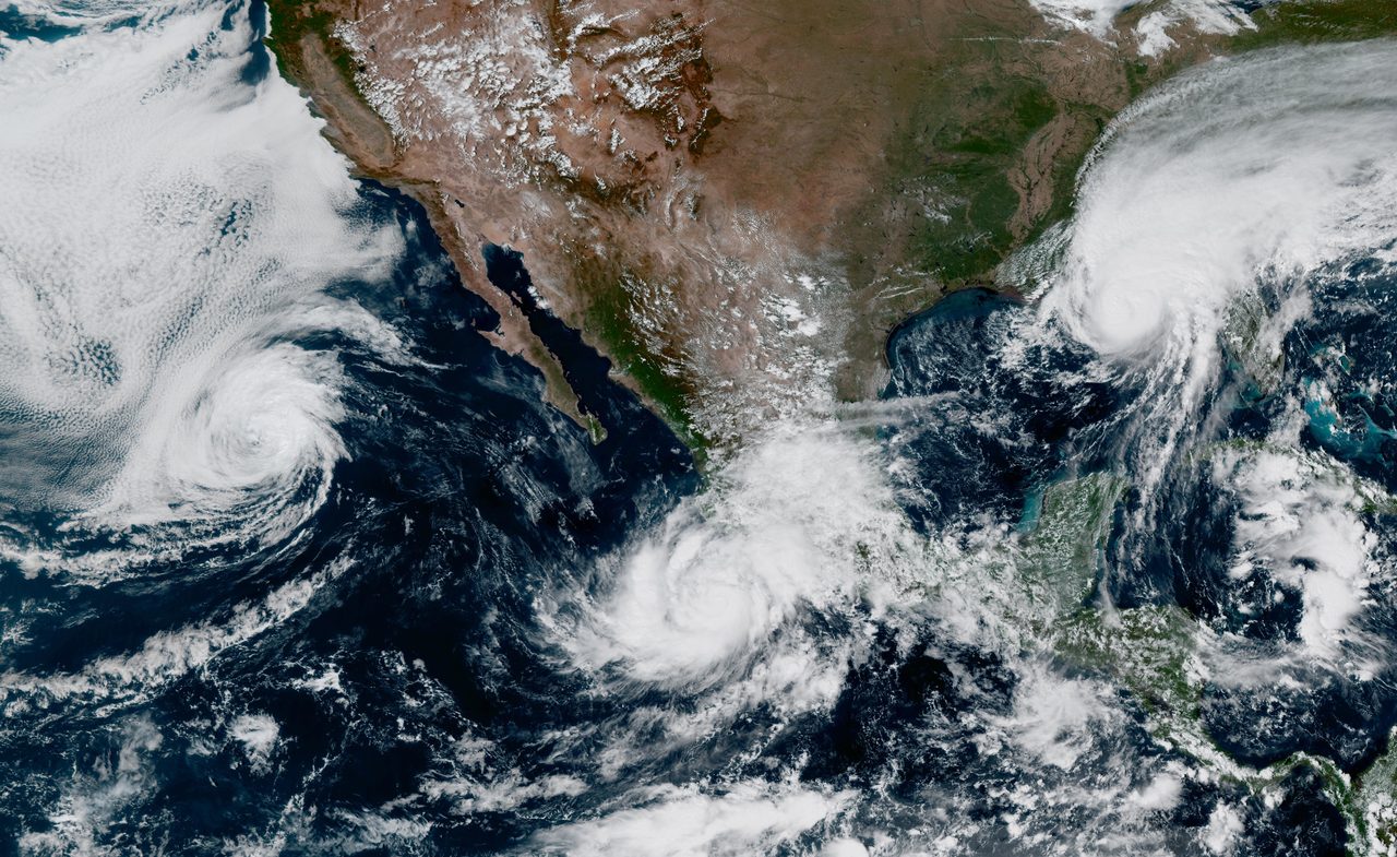
October 11, 2026 is ending with tropical weather driving much of the global risk picture. Hurricane Simon remained an extremely dangerous storm just off Mexico’s west-central coast this morning, while the remnants of Rachel spread heavy rain, flooding risk and gusty winds from Baja California into the U.S. Southwest. In the eastern United States, moisture tied to Post-Tropical Cyclone Isaias kept a flood and severe-weather threat alive from the Carolinas into the Mid-Atlantic. Elsewhere in the U.S., forecasters also highlighted coastal flooding in Southern California, elevated fire-weather concerns in northern California, and smoke impacts in multiple states.
Past 24 Hours
Globally, the most consequential weather event in the past day was Hurricane Simon in the eastern Pacific. The National Hurricane Center said at 6:00 AM CST that Simon was moving north-northwest near the west-central coast of Mexico with maximum sustained winds of 150 mph, placing the core of the hurricane very near the coast. Because named-storm status, position and intensity come directly from NHC, Simon leads today’s briefing on source confidence and life-safety threat alone, even as other hazards continue elsewhere.
Across the U.S. Southwest and northwestern Mexico, Post-Tropical Cyclone Rachel continued to produce heavy rain and gusty winds. The NHC said Rachel was bringing 1 to 3 inches of rain, with local amounts up to 5 inches from Southern California into the Great Basin and portions of the Southwest, with the potential for significant flash and urban flooding. Local National Weather Service offices in Los Angeles and Hanford also highlighted flood watches, coastal flooding concerns, rain impacts and mountain snow tied to the storm system.

In the Southeast and Mid-Atlantic, the remnants of Isaias also remained a significant weather story. The Weather Prediction Center’s Day 1 Excessive Rainfall Outlook placed a moderate flash-flood risk over parts of the interior West and slight-risk areas in both the Mid-Atlantic and the Southwest, while the Storm Prediction Center warned that isolated severe wind gusts and a tornado or two were possible from North Carolina into Virginia. Weather.gov’s national headline also emphasized flooding risks from tropical moisture across both the Intermountain West and the East Coast.
What’s Happening Now
As of this morning’s official updates, Simon remained the most dangerous active tropical system in the region. NHC said the storm’s core was very near the coast of west-central Mexico, with hurricane conditions and heavy-rain hazards continuing to demand close monitoring there. Rachel, although post-tropical, was still active as an inland-impact system, with gusty winds spreading over higher terrain in the Southwest and coastal flooding and erosion concerns lingering along parts of Southern California and northern Baja California.
Southern California’s local NWS office warned that widespread minor to moderate sea-water flooding of beaches, walkways and low-lying roads was possible, with localized damaging flooding considered likely in some warning areas and the highest risk around Sunday morning high tide. That coastal-flooding signal stands apart from Rachel’s inland rain threat and remains one of the more immediate U.S. hazards at the close of the weekend.

Beyond tropical hazards, AirNow continued to flag wildfire smoke impacts in multiple states, and its national alert urged people to check the Fire and Smoke Map for local conditions. In northern California, the Storm Prediction Center also maintained an elevated fire-weather area for the northern Sacramento Valley, citing dry fuels, low humidity and locally gusty post-frontal winds.
Outlook Through Tonight
Through 11:59 PM ET, the main forecast concerns are clustered in three zones. First, Simon will remain the top international life-safety concern near Mexico. Second, Rachel’s moisture plume will continue to support flooding issues from Southern California into parts of the Great Basin and Southwest, while some Sierra areas pick up early-season snow. Third, Isaias’ remnant circulation will keep a corridor of heavy rain and isolated severe weather possible in parts of the Mid-Atlantic.
The SPC’s Day 1 outlook calls for a slight risk of severe thunderstorms across parts of North Carolina and Virginia, with isolated damaging gusts and a tornado or two possible. The WPC’s Day 1 rainfall outlook shows more than one active flood corridor nationwide, underscoring that today’s weather story is not confined to one coast or one storm track.
In the Pacific Northwest and northern Rockies, colder air is also beginning to show up more clearly, with light mountain snow and freeze-related concerns noted by local forecast offices. Those are not the headline global hazards tonight, but they are a reminder that the broader North American pattern is becoming more complex as tropical moisture interacts with early-season cold air.
Overall, the end-of-day picture is dominated by verified tropical and flood hazards on both sides of North America: a dangerous hurricane near Mexico, a post-tropical rain and flood producer in the Southwest, and lingering flood and severe-weather risks in the East.




