
Global Weather Briefing for October 8, 2026
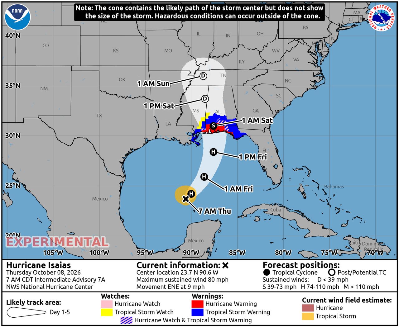
Hurricane Isaias is the standout weather threat heading into Thursday night, with the National Hurricane Center warning of dangerous storm surge, damaging winds and heavy rainfall along the northern Gulf Coast. Elsewhere, wildfire smoke remains a concern across parts of the western United States, and severe thunderstorm and heavy-rain risks continue in parts of Florida and the central U.S. Internationally, global monitoring services continue to flag active flood concerns in several countries, though some event-level details were not fully available from primary agencies during this update window.
Past 24 Hours
Over the past day, the most consequential weather development has been the strengthening of Hurricane Isaias in the Gulf of America. As of the National Hurricane Center’s latest Thursday morning update, Isaias had reached hurricane strength with maximum sustained winds of 80 mph while moving east-northeast in the Gulf. The official NHC homepage said preparations to protect life and property from storm surge and damaging winds along the warning area of the Gulf Coast should be rushed to completion today, underscoring that impacts are nearing the coast even before landfall.
In the western United States, wildfire conditions remained nationally significant. The National Interagency Fire Center reported 10 large active fires being suppressed across California, Nevada, Oregon and Washington, with 486,543 acres burning in those active incidents. NIFC also said firefighters and support personnel remained deployed at scale, while dry air and above-normal warmth continued to support elevated fire-weather concerns in parts of the West.

Outside the U.S., the global baseline did identify active flood monitoring in places including Spain, Nigeria and Vietnam on the GDACS dashboard. However, because sufficiently current event-specific impact details were not fully available from primary agencies within the research window, those international flood situations are best treated here as active global concerns rather than ranked above the better-verified U.S. cyclone and wildfire threats.
What’s Happening Now
The immediate headline is Hurricane Isaias. On the NHC’s Thursday update, hurricane warnings were in effect along parts of the northern Gulf Coast, and the agency warned that damaging hurricane-force winds, life-threatening storm surge impacts and heavy rainfall were expected Friday into the weekend. NHC also reported Hurricane Hunter aircraft were investigating the storm Thursday morning. With Isaias already at 80 mph and a minimum central pressure of 975 mb, the storm remains the clearest near-term life-safety risk in the global weather picture.
Elsewhere in the U.S., the Storm Prediction Center placed parts of the Florida Peninsula under a marginal severe thunderstorm risk for Thursday, with a few organized storms capable of producing near-shore waterspouts or a brief tornado. SPC also highlighted a separate late-night hail risk from elevated thunderstorms across parts of Iowa and the middle Missouri Valley.

Air quality is also being affected by wildfire smoke in multiple states, according to AirNow, which posted a national system alert Thursday noting smoke impacts in multiple states and directing users to its Fire and Smoke Map for local conditions. That makes smoke exposure a continuing public-health hazard, even in areas far from active flames.
Outlook Through Tonight
Through 11:59 p.m. ET tonight, the most important forecast message is that Gulf Coast preparations for Isaias should be completed as the storm continues approaching. The NHC expects a strong hurricane to near the northern Gulf Coast on Friday, so tonight is a narrowing window for final protective actions in warning areas.
For the rest of today and tonight, SPC says localized severe thunderstorms may continue across the middle Florida Peninsula, while additional storms may develop later across parts of the Upper Midwest and middle Missouri Valley. The Weather Prediction Center also shows a Day 1 excessive-rain area affecting a population of more than 14 million people, signaling at least a localized flash-flood concern where repeated heavy downpours set up.
In the West, fire-weather concerns remain elevated where low humidity and warm conditions persist, even though the strongest wind signals are limited in California and Nevada today. Smoke impacts may continue to shift downwind into communities well away from the largest fire perimeters.


.png)