
Daily Weather Briefing for October 9, 2026

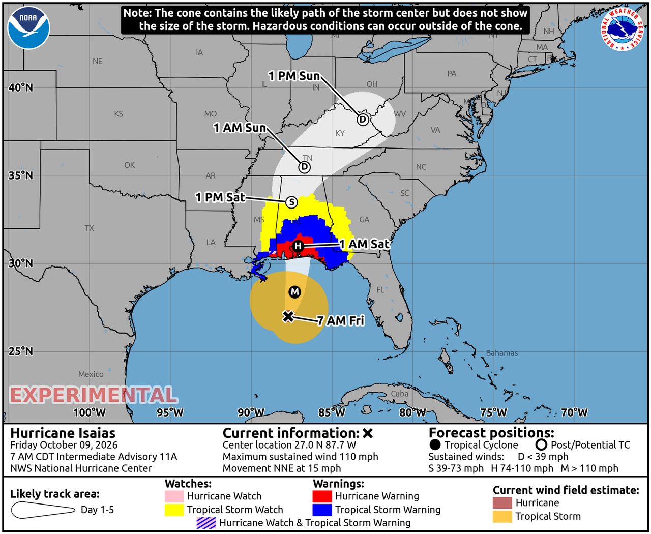
Hurricane Isaias dominated the weather picture over the past 24 hours after strengthening over the Gulf and heading toward the northern Gulf Coast. The National Hurricane Center said Friday morning that Isaias had become a major hurricane with 120 mph winds and was expected to make landfall near Pensacola by early evening, while the Storm Prediction Center warned that rainbands could also produce tornadoes from the Florida Panhandle into southeast Alabama and southwest Georgia.
Past 24 Hours
The most significant observed weather development in the past day was the rapid intensification of Hurricane Isaias over the Gulf of Mexico. On Friday morning, the National Hurricane Center said the storm had strengthened into a major hurricane with maximum sustained winds of 120 mph and a central pressure of 959 mb. Across the broader U.S. hazard picture, AirNow also continued to flag wildfire smoke impacts in multiple states, underscoring that air quality remains a meaningful weather-related health issue even outside the tropics.
Elsewhere, the global weather baseline continued to show active flood disasters in parts of Europe and Asia, with GDACS listing flood events in Spain, Chile, Nigeria and Vietnam over the last two days. However, the directly accessible source material available in this run did not provide enough verified impact detail to responsibly rank those events above the best-documented cyclone threats from U.S. and eastern Pacific agencies.
What’s Happening Now
As of Friday morning, Isaias remained the clearest immediate life-safety threat. The NHC advisory placed the center near 27.0°N, 87.6°W, moving north-northeast at 15 mph, with dangerous storm surge, damaging winds, heavy rainfall and tornado potential near and inland from the Gulf Coast. The National Weather Service homepage also highlighted a life-threatening storm surge and widespread heavy rain threat across much of the Southeast.

In the eastern Pacific, Hurricane Simon was also an important active hazard. The NHC said Friday morning that Simon was forecast to approach the coast of Mexico this weekend as a dangerous major hurricane. At that advisory, Simon was located near 15.9°N, 104.5°W with maximum sustained winds of 90 mph. While the most serious impacts were still forecast to come later, the storm was already a major regional concern because of its expected approach toward southwestern Mexico.
Tropical Storm Rachel remained weaker than Simon, but still warranted close monitoring for Baja California, northwestern Mexico and the U.S. Southwest. The Friday morning NHC advisory said Rachel had 50 mph winds and could bring 1 to 3 inches of rain, locally up to 5 inches, to parts of the Southwest this weekend, along with flash-flood potential, gusty winds in higher terrain, and dangerous surf and rip currents along parts of Southern California and northern Baja California.

Wildfire smoke remained another ongoing concern. AirNow’s national alert page said smoke was affecting air quality in multiple states, though the homepage snapshot available here did not specify the full state list. That means the signal is strong enough to note nationally, but not strong enough in this run to make a more detailed state-by-state claim.
Outlook Through Tonight
Through 11:59 p.m. ET, the highest-confidence forecast hazard is Isaias pushing toward landfall on the northern Gulf Coast. NHC and SPC guidance together point to a corridor of coastal wind, surge, heavy rain and tornado risk from the Florida Panhandle into parts of Alabama and Georgia. The Weather Prediction Center’s Day 1 Excessive Rainfall Outlook also shows millions of people within slight and moderate flash-flood risk areas.
Beyond the Gulf Coast, the eastern Pacific remains unusually busy. Simon is expected to continue threatening the coast of Mexico, while Rachel is expected to keep drawing attention in Baja California and the Southwest because of its moisture plume, surf and localized flooding potential later in the weekend. Fire-weather and smoke concerns also remain in the background in the U.S. West, though the strongest verified near-term headline in this cycle remains tropical.




