
Global Weather Briefing for October 2, 2026
Published for Friday, October 2, 2026, in Eastern Time.
Past 24 Hours
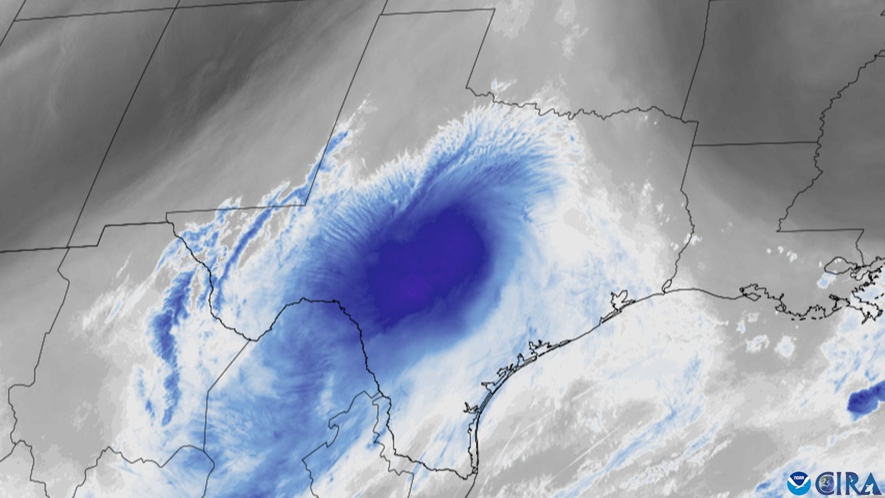
Flooding remained the most consequential weather story in the United States over the past day. The National Weather Service highlighted heavy rain continuing across south-central Texas, with a slow-moving front sustaining the threat of flash and urban flooding. The Weather Prediction Center’s Day 1 Excessive Rainfall Outlook shows a Slight Risk area with more than 15 million people affected and a broader Marginal Risk area covering more than 34 million people, underscoring the scale of exposure even before tonight’s additional rainfall arrives.
Elsewhere in the U.S., heat was the other major headline. The National Weather Service said abnormally hot to potentially record-breaking temperatures were affecting southern California and extending north toward the Bay Area and Central Valley. This is primarily an ongoing life-safety story tied to prolonged exposure and warm overnight conditions rather than a single dramatic event, but it remains one of the most important hazards in place today.
Outside the U.S., flood recovery remained a meaningful part of the global weather picture. In India’s Andhra Pradesh, reporting from The Hindu said relief reached 720 families in Srikakulam district after recent flooding, with local infrastructure repairs continuing and crop losses reported across thousands of acres. Because the article focused on relief and recovery, not a fresh disaster bulletin, it is best read as evidence that flooding impacts remained significant within the past day rather than as a new escalation.

Air quality also stayed elevated as a practical hazard in parts of the country. AirNow posted a system alert for wildfire smoke affecting multiple states, a reminder that even where flames are distant, smoke remains a health risk for sensitive groups and can worsen quickly with shifts in wind.
What’s Happening Now

The most immediate active hazard continues to be the flood threat in Texas and along parts of the Gulf Coast and Southeast. Weather.gov’s national headline and WPC guidance both indicate that repeated rounds of rain remain capable of producing flash flooding, especially in urban corridors and places that have already seen heavy rainfall. This is the clearest active weather story because it combines broad population exposure with near-term life-safety risk.
In California, dangerous heat remains active. Weather.gov warned that abnormally hot and potentially record-breaking temperatures would continue across southern California and spread northward toward the Bay Area and Central Valley. The persistence of the heat matters: repeated hot days and limited nighttime cooling increase health stress, especially for people without reliable cooling.
In the broader tropics, the National Hurricane Center said there are no tropical cyclones in the Atlantic at this time, but it is issuing advisories for Hurricane Rachel in the eastern Pacific and Tropical Storm Nolo in the central Pacific. Based on the latest NHC information available, neither system is the day’s top global weather story because the stronger confirmed land-impact signal remains with flooding and heat elsewhere.

Smoke remains another active cross-border hazard. AirNow’s nationwide smoke alert and satellite-based smoke imagery from recent North American events help show how widespread smoke transport can become when large fires and favorable wind patterns line up, even though the exact smoke footprint changes from day to day.
Outlook Through Tonight
Through 11:59 p.m. ET, the flood threat remains the top concern. WPC’s Day 1 outlook keeps a broad excessive-rainfall risk in place, and the National Weather Service continues to flag flash and urban flooding potential from Texas eastward toward the Gulf Coast and Southeast. The Storm Prediction Center, by contrast, said organized severe thunderstorm potential is low today and tonight, so flooding is the bigger concern than classic severe-weather outbreaks.
Heat will continue to build or hold across California into tonight, with the greatest concern where high daytime temperatures are followed by poor overnight cooling. Even where records are not set, the cumulative effect of prolonged heat can be dangerous.
For smoke-sensitive areas, conditions may remain uneven into the evening depending on local winds and nearby fire activity. AirNow’s current alert is a useful reminder that air quality can deteriorate faster than skies alone suggest, especially for children, older adults, and people with respiratory conditions.
Globally, today’s strongest verified weather signals remain centered on heavy rain and flooding in parts of the United States, ongoing heat in California, and continuing flood recovery impacts in parts of India. Some global baselines were limited or unavailable through this workflow, so only claims supported by the accessible official or credible-source material have been included here.


.png)
.png)
.jpg)