
Could a Very Strong El Niño Be Taking Shape? What It Means for Weather This Year
Climate Patterns • El Niño • Weather Preparedness
Could a Very Strong El Niño Be Taking Shape? What It Means for Weather This Year
El Niño is back in the weather headlines, and recent forecasts suggest this event could become one of the stronger El Niño episodes in recent history. While some media reports use phrases like “super El Niño,” NOAA’s official terminology is more specific: weak, moderate, strong, or very strong El Niño.
According to NOAA’s Climate Prediction Center, El Niño is currently present and is expected to strengthen through the end of 2026. NOAA also says there is a high chance that El Niño will continue into early spring 2027.
For everyday weather watchers, the important question is simple: what could this mean for storms, rainfall, winter weather, hurricane season, and local conditions?
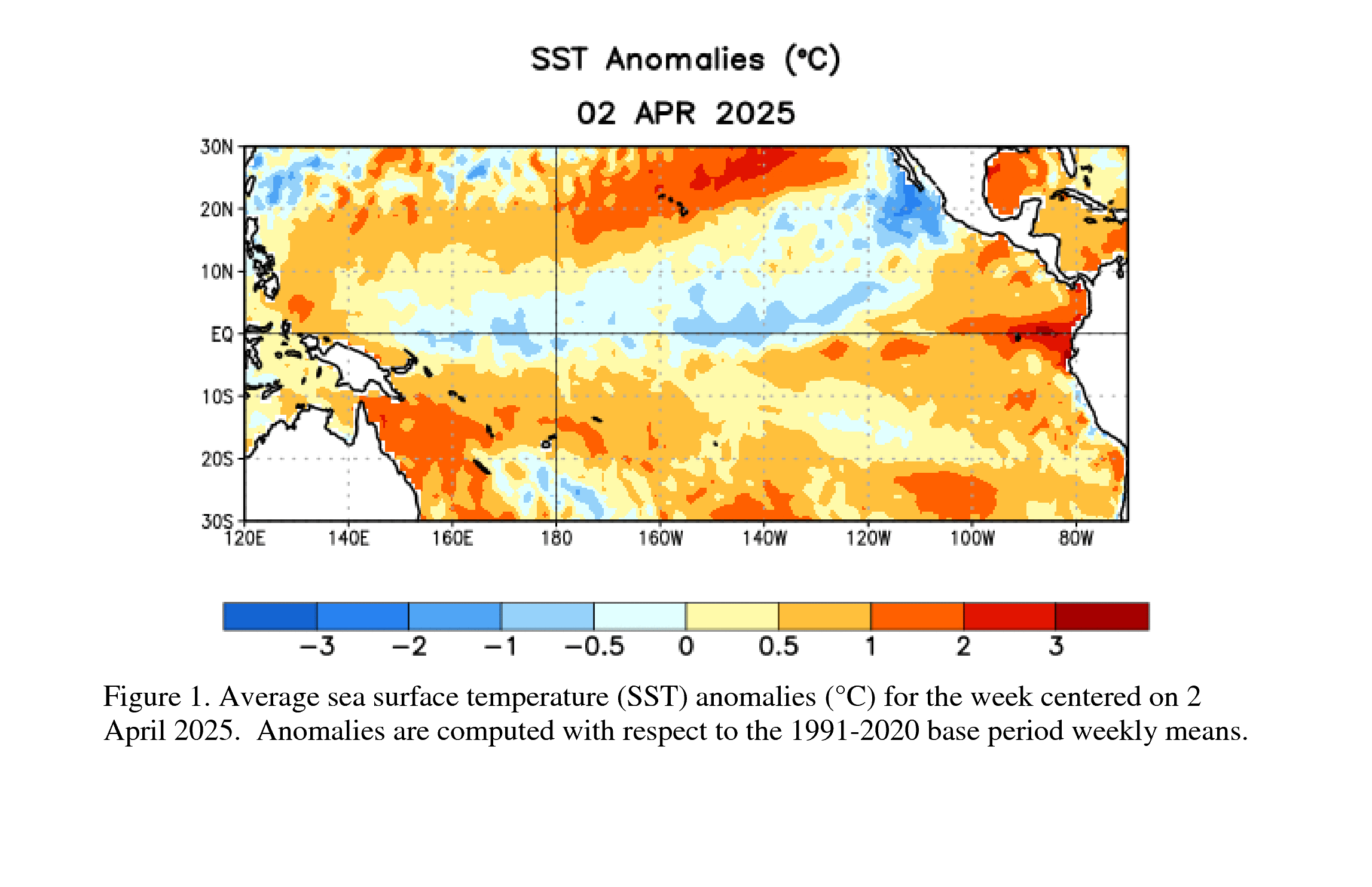
What is El Niño?
El Niño is the warm phase of the El Niño-Southern Oscillation, often shortened to ENSO. It occurs when sea surface temperatures in the central and eastern tropical Pacific Ocean become warmer than average for a sustained period.
That warming may sound far away from the United States, but the tropical Pacific has a major influence on global weather patterns. When the ocean and atmosphere become strongly coupled during El Niño, the jet stream, rainfall patterns, tropical cyclone activity, and temperature patterns can shift across large parts of the world.
Every El Niño is different. Some are weak and have limited impacts. Others become strong enough to significantly tilt the odds toward certain weather patterns, especially during fall and winter.
Why people are talking about a “super” El Niño
The phrase “super El Niño” is commonly used in headlines, but it is not the main official NOAA category. NOAA’s Climate Prediction Center uses strength categories such as weak, moderate, strong, and very strong, based on sea surface temperature departures in the Niño 3.4 region of the tropical Pacific.
For late 2026, NOAA’s official probability table shows a high chance of a very strong El Niño during the October–December period. That does not guarantee extreme weather in every location, but it does mean the climate pattern may be strong enough to have a larger influence on seasonal weather.

What NOAA is currently forecasting
NOAA’s latest ENSO Diagnostic Discussion says El Niño has strengthened over the past month, with above-average sea surface temperatures across the central and eastern equatorial Pacific. NOAA also notes that the ocean and atmosphere are showing signs of strong coupling, which is an important signal when evaluating whether El Niño will continue to intensify.
The key forecast points are:
- El Niño is currently present.
- El Niño is expected to strengthen through the end of 2026.
- NOAA gives El Niño a high chance of continuing into early spring 2027.
- The October–December 2026 period has a high probability of reaching very strong El Niño levels.
That makes this a climate signal worth watching closely over the next several months, especially heading into fall and winter.
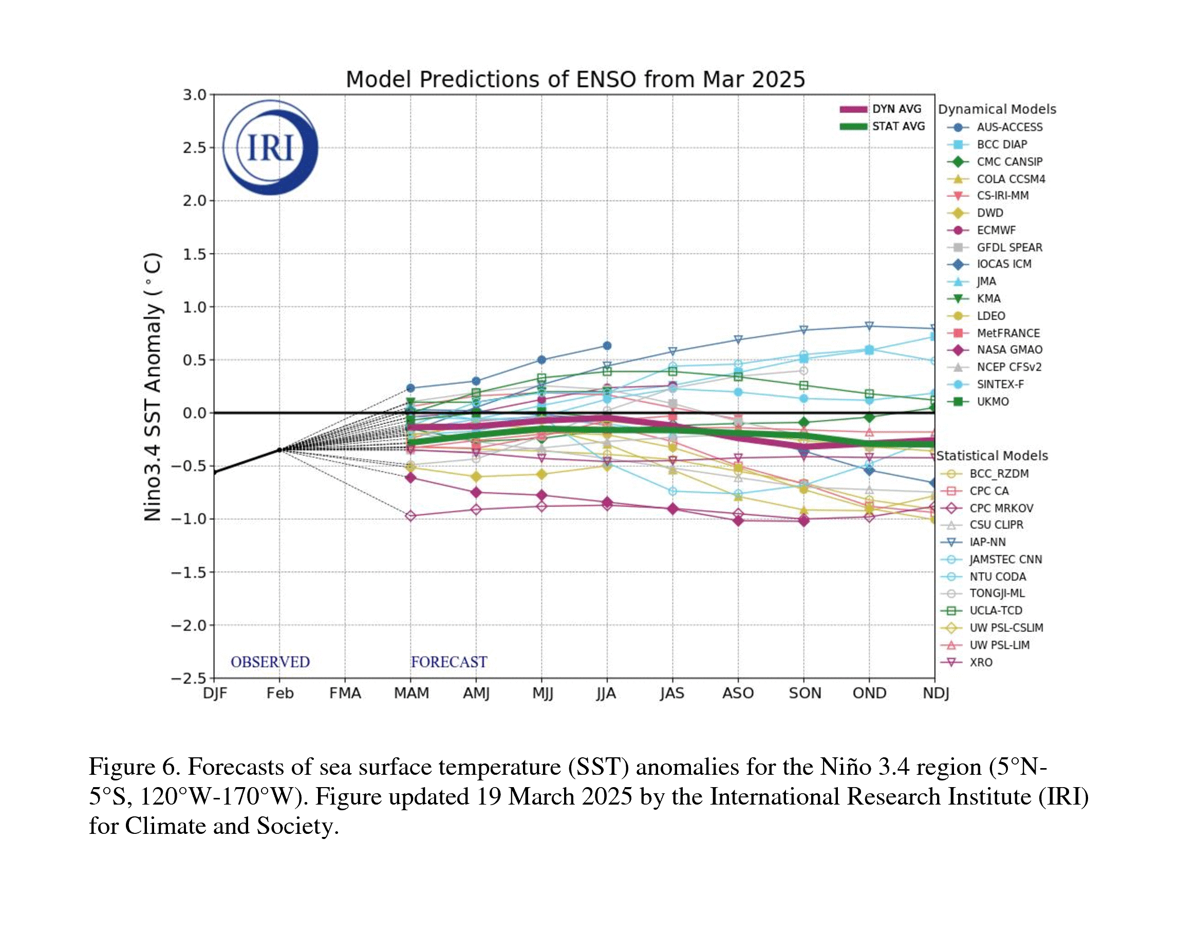
How El Niño can affect weather patterns
El Niño does not create the exact same weather in every event, but it often shifts the odds for certain patterns. The stronger the event, the more influence it can have on seasonal weather, though local impacts still vary.
Common El Niño influences can include:
- A stronger Pacific jet stream, which can shift storm tracks.
- Increased rainfall chances across parts of the southern United States during winter.
- Drier or warmer tendencies in some northern areas, depending on the season and region.
- Changes in global rainfall patterns, including flood risk in some regions and drought risk in others.
- Higher global temperature influence, especially when a strong El Niño occurs on top of already warm oceans.
These are broad climate signals, not local day-by-day forecasts. A strong El Niño can increase the probability of certain outcomes, but it does not guarantee them for every city or state.
What this could mean for hurricane season
El Niño often reduces Atlantic hurricane activity by increasing vertical wind shear across parts of the tropical Atlantic. Wind shear can disrupt developing tropical storms and make it harder for thunderstorms to organize into hurricanes.
That said, El Niño does not eliminate hurricane risk. Even in a quieter Atlantic season, one storm in the wrong place can cause major impacts. Warm ocean waters, local atmospheric conditions, and short-term weather patterns still matter.
The right approach is to avoid assuming that El Niño means “no hurricanes.” It is better to view El Niño as one factor among many. Coastal residents should still prepare, monitor the tropics, and follow official National Hurricane Center updates throughout the season.
Why this matters beyond the tropics
El Niño can influence more than hurricane season. It can also affect winter storm tracks, heavy rain potential, drought risk, flooding patterns, wildfire conditions, and temperature swings. In some areas, the main concern may be too much rain. In others, it may be dryness, warmth, or an unusual winter pattern.
Because impacts vary by region, users should pay attention to local forecasts rather than relying only on national headlines. A very strong El Niño may be a major climate story, but your local risk still depends on where you live and how the atmosphere responds week to week.
How WeatherScope can help users stay ahead
WeatherScope is built to help users track changing weather conditions in real time. During an active El Niño pattern, that can be especially useful because weather systems may shift quickly and impacts can vary widely from one region to another.
WeatherScope helps users monitor:
- Live radar for rain, storms, and changing precipitation patterns
- Storm tracking for tropical systems and severe weather threats
- Weather alerts for changing local conditions
- Lightning alerts during thunderstorms
- Forecast overlays for wind, precipitation, pressure, humidity, cloud cover, and more
- Interactive weather maps for regional and local awareness
- Custom radar color themes so users can personalize how they view radar data
- Apple Watch radar for fast access to weather information from your wrist
Whether El Niño brings wetter weather, stronger storm systems, changing winter patterns, or shifting tropical activity, WeatherScope gives users tools to monitor what is happening now and what may be coming next.
Preparedness tips for an El Niño-influenced season
A strong El Niño is not something to panic about, but it is something to prepare for. Since impacts vary by region, the best plan is to stay flexible and weather-aware.
- Review your local flood risk before heavy rain events.
- Keep emergency alerts enabled on your phone.
- Monitor local National Weather Service forecasts during active weather.
- Have a way to track storms and radar in real time.
- Prepare for possible power outages during winter storms or severe weather.
- Do not drive through flooded roads.
- Continue hurricane preparedness if you live near the Gulf Coast, Atlantic Coast, or Caribbean.
El Niño changes the background pattern, but local weather still requires local awareness. Staying informed is the best way to stay ahead.
Bottom line
El Niño is strengthening, and NOAA’s latest outlook suggests a very strong event is possible later in 2026. While headlines may use dramatic wording, the practical message is straightforward: this climate pattern could influence weather around the world and may affect rainfall, winter storms, temperatures, and tropical activity.
WeatherScope can help users monitor those changing conditions with live radar, alerts, storm tracking, and forecast visualization tools.
Stay weather-aware this El Niño season with WeatherScope.
Image use and licensing
The images used in this post are NOAA/NWS Climate Prediction Center graphics. NOAA states that most NOAA information and imagery is in the public domain unless otherwise noted. Credit is still recommended, and each image above includes NOAA/CPC attribution.
Daily Mail images were not used because news article images are typically copyrighted or licensed for that publisher’s use.
Sources
- NOAA Climate Prediction Center: ENSO Diagnostic Discussion
- NOAA CPC: Official ENSO Strength Probabilities
- Columbia Climate School IRI: ENSO Forecast
- NOAA AOML: How El Niño Impacts Atlantic Hurricane Season
- NOAA Climate.gov: El Niño and U.S. Winter Precipitation
- NOAA Photo Library Usage and Public Domain Guidance
- WeatherScope

